
California \ North Pacific Coast Railroad \ Glimpses of the Ghost
Glimpses of the Ghost.
Tracing the route of the North Pacific Coast Railroad.By Boone Morrison
Introduction:
Boone created the original version of this paper after a visit to the region in August of 1996. Since then, a group of NPC fans and researchers have uncovered a lot more information. Boone's been a catalyst for this.
The editorial additions represent an independent effort. The research was sparked by my grandmother's stories of the NPC, my land surveying activities in Marin and Sonoma Counties, and a lot of time tracing the ROW on foot, car, hiking, and via kayak. The notes are a compilation of subdivision and boundary maps, aerial imagery, railroad maps, and Google Earth. There are only a few sections where we just haven't uncovered adequate information to accurately retrace the ROW.
A surprising amount of the ROW is publicly accessible today. After the abandonment, many ROW segments became the foundation for street surfaces, county roads, and fire trails. As one travels north on the line especially, many of these surfaces represent private roads.
Within northern Marin County and Sonoma County the ROW is NOT ACCESSIBLE and lies on privately held lands. The property owners generally will not allow access to casual visitors and a few are openly hostile to visitors. Do respect this fact.
In future revisions we will expand this document to include major expansions the NPC/NS/NWP made to yard areas and other locations on the line. Examples include the Sausalito pier and yard, Duncan's Mill, spur additions, abandonments, and other similar features. Check back periodically.
Craig Hoefer. July 2009
Report of a five day field trip tracing the route of the North Pacific Coast RR.
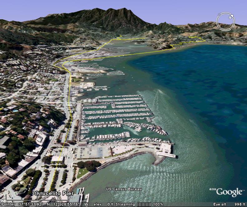
Saucelito to Fairfax: Basically nothing of note remains save a few places where broad gauge NWP tracks are in place along the old ROW. A new jogging trail from Mill Valley across the marsh to Saucelito is on the old ROW, but little else can be seen.
Click To Enlarge
 |
Click To Enlarge
 |
| Waterfront | Yard Area |
- Across Richardson's Bay the Strawberry Peninsula's eastern side hosted the original ROW. Through here, and up through the hills to Corte Madera the ROW has effectively been obliterated.
- Reminants may lie under Heron Drive on the peninsula and under the homes along the shore.
- As one travels toward the hill, Bay Vista Drive appears to correspond well with existing documentation.
- Somewhere north of this road, the HWY 101 highway cut has obliterated the crossing to the Corte Madera side of the ROW.
- Meadowsweet Drive at this point has the best fit for the original ROW.
- Following this, Manzanita Avenue to Chapman Drive. The ROW is then obliterated by a subdivision.
- The ROW then broadly curves to the northwest onto the north side of Monticito Drive to Holcomb Avenue. The ROW is to the easterly side.
- Holcomb Avenue swings to the west, the ROW continues strait and intersects with Magnolia Avenue at a park at the intersection with Doherty Avenue.
- The ROW parallels Magnolia Avenue on the north side of the street. It leaves this street just southeast of Ridgecrest Road. The ROW is oblterated until Bon Air Road.
- Tulane Drive is roughly on the ROW until it intersects with tidal lands.
- The structures between the marsh and Magnolia lie roughly on the ROW.
- Magnolia turns north and becomes College Avenue.
- The structures on the east side of Kent Avenue are the ROW.
- The ROW continues on a strait line north westerly as defined by Kent and the structures. The ROW becomes obliterated by a subdivision. It essentially is defined by the creek to the northeast and the adjoining residential properties. Follow Kent Avenue, then Poplar Avenue to Lagunitas Road.
- Turn Left on Sylvan Lane. The ROW is roughly under the homes to the East.
- After Yosemite Avenue, the ROW joins Sylvan Lane at the end far end of the tennis court. It continues obliterated until Bolinas Avenue.
- The ROW lies between Sir Francis Drake and San Anselmo Avenue. It then parallels Sir Francis Drake's westerly side north of Ross Avenue. This continues to the major intersection at Greenfield Avenue.
- Welcome to the San Anselmo Junction.

- Red Hill Avenue (and Greenfield Ave) represents the ROW to San Rafael.
- At Hilldale Ave. 4th St. becomes the ROW.
- At the intersection follow the right fork onto 2nd St.
- Ida St. and G St. Represents the site of the West End Station.
- At Shaver St. The ROW split to approach a yard facility. The northerly line followed 2nd St. The southerly line continued in a strait line through the southerly bock on the street. Evidenced by the parking area mid-block.
- Following C St. the ROW curved to the southeast mid-block between CSt. And B St.
- The ROW is evidenced by the Bar (a parallelogram structure) at the southeast block, intersection of 2nd and B st.
- This block is the location of the bulk of the San Rafael Station and Yard. Todaqy it is a Grocery Store and parking.

- Anderson Drive represents the ROW. Follow through to the waste treatment facility.
- From this point to the Richmond-San Rafael Bridge the ROW is obliterated. The Rod and Gun Club is the likely location of the old Ferry at Point San Quinton.
San Anselmo to White's Hill
- Follow Center Blvd. west to Pastori Avenue. The ROW curves left at the grocery store and follows the parking between Center and Sir Francis Drake Blvd.
- Center becomes Broadway Blvd then curves northerly. Following this parking area, the ROW passes through buildings and then through additional parking.
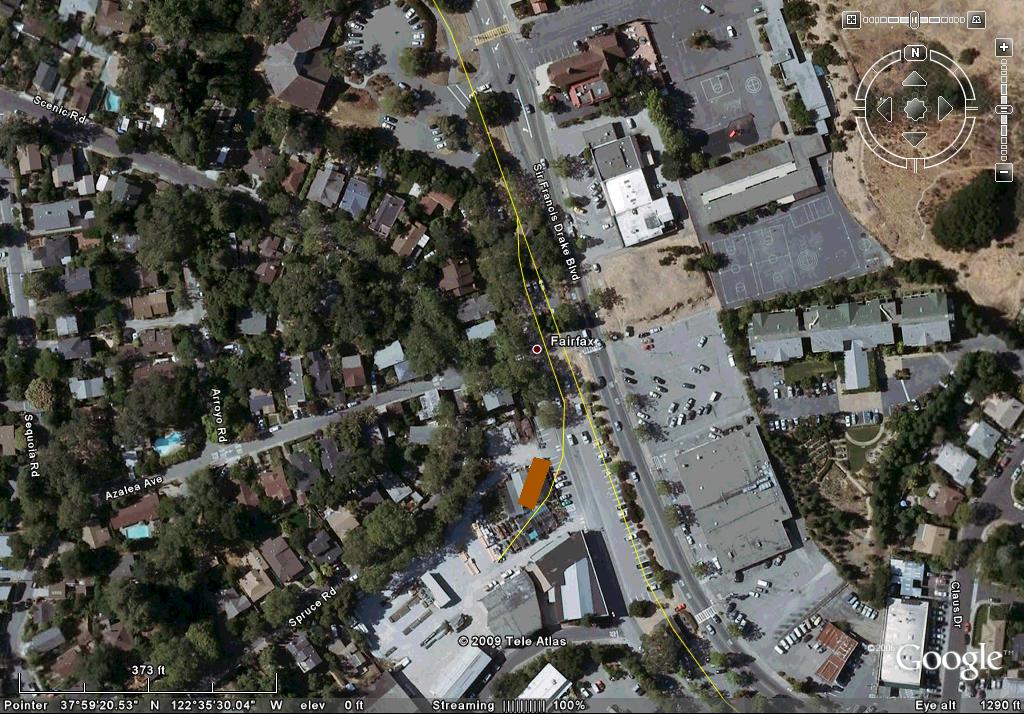
- Enter Fairfax. Just north of Azalea Ave. was a spur to the southwest that serviced the Fairfax Mill platform.
- Follow Sir Francis Drake Blvd. northwesterly. ROW.
- At Mitchell Dr. the ROW leaves Sir Francis Drake Blvd. and travels northwest through an apartment complex.
- Turn Right on Glen Drive. ROW.
- The end of Glenn Drive becomes the entrance to Dutch Valley Ln. Travel approximately .2 miles to a dirt trail to the left. Follow this fire road for the White's Hill grade. I have not been on this segment and have no knowledge of accessibility to the point where the ROW approaches Baywood Canyon Road.

Whites Hill to Tocaloma: The south portal of the new (1904) "bypass" route through Whites Hill is still in place, though access is via a fire road (the ROW) that is privately held. If you want to look at the entry point drive out of Fairfax about two miles until you come to the sign for the "Henry Bothin Youth Center" on the right as you are headed north. Turn in (be prepared for "no parking" signs and questions from Youth Center folks). The youth center gate is on the left and a gate on the fire road is to the right. The sign says "welcome to the Marin recreation area...", but that is a sham, since about fifty yards farther along is another gate stating that it is private property, keep out. At any rate, you are standing on the ROW and the tunnel mouth is about a mile and a half ahead of you.
Scuttlebutt has it that the youth center folks claim their property extends to the right of the road, the County thinks their land includes the road. Basically you are stepping into a minor turf war between the good ladies of the youth center and the county of Marin...good luck!
After being thrown out of this area you can continue on over the hill and achieve the San Geronimo Valley, site of Woodacre, San Geranimo and Lagunitas. Continue along the main highway until you have just passed the golf course on the left. To the right at the base of the hills you can catch glimpses of the original (pre 1904) ROW. At the end of the golf course you will see a new church and a left turn off the main road. Take this turn. Immediately after the turn you can again turn right into a parking area behind the church and its pre-school. Just north of the church is the San Geronimo depot. Remember, this is all private property and you should respect that fact. After looking at the depot you can go back out of the parking area, but this time turn to the right and immediately left again onto the original road that runs through the Woodacre residential area. You are basically on the ROW at this point and will note that it is Railroad Street. Not surprising. Continue along this street about a mile and you will come to the entry to the Marin County Fire Department Headquarters complex. That is also the ROW and if you take the road to the left of the entry you can parallel the old ROW and come to the back of the Fire Department buildings. Here is the begining of the cut that lead to the tunnel mouth, which has been blasted closed in recent years. Returning to the main highway, continue to Lagunitas, about two miles farther along. On the right you will see a stucco building with a singular curve to the false front. This store was in place as early as 1890 and is seen in two different photographs in NGR. The depot was in the clear area approximately 75 yards farther along and across the present road.
Continuing on from Lagunitas you will pass through Samuel P. Taylor State Park. Here the ROW is visible along Paper Mill Creek for several miles. Initially it is on the right as you travel north, across the creek from the highway. About three miles into the Park there is a footbridge crossing the highway that rests on old NPC abutments. You can park a few yards south of this footbridge and walk into the picnic area. As you enter the area look up to your left and you will see the ROW as a horse/hiking trail. If you wish you can follow it in either direction for several miles through the canyon.
Samuel P. Taylor State Park has an easy trail popular for hiking and bicycling. The main trail is the ROW. One can travel to the old Paper Mill site.
North of the Park's north boundary the ROW continues to the intersection of Plank Bridge Road. Just west of this intersection is a road called Taylor Park Road. It is the ROW until one reaches a building. The ROW passed through the building footprint and continued along the road. I have not traveled this road and do not know accessibility.
Continuing from Taylor State Park follow the signs to Tocaloma. Now no more than a fork in the road, there are some barns and a house that were likely (no confirmation) there in RR days. The ROW swung to the right, largely following the route of the present road on its left. If you wish, leave your vehicle and follow the signs to the Trans Marin Hiking Trail. Again, this is the ROW and can be followed south for several miles, connecting to the portion in Taylor State Park. The northern direction from here is on private land and is not open to the public.
- Turn Left onto Point Reyes-Petaluma Road. The ROW is across the creek and on private lands.
- You will be traveling in a northwesterly direction. You will travel around a significant bent to a westerly direction. Across the creek will be ranch buildings. The ROW passed through these structures.
- At a point approximately .07 miles before the intersection with the Shoreline HWY (HWY 1) was the site of a bridge over the creek and the site of a major derailment.
From Tocaloma to Pt. Reyes Station the ROW is difficult to follow but in Pt. Reyes town there are a number of interesting glimpses to be found. You will arrive at a junction and should turn left towards the center of town. Turn left again at the main street (you are now headed south again) and follow it. On the left is the original depot, now restored and used as the Post Office. Many of the buildings on the opposite side of the street are from NPC days and are an excellent example of the architecture of the time.
The other railroad building in town is the second engine house, built in 1920 when the line south of here was broad gauged. Follow the main street, this time to the north. Look for a prominant light blue Victorian building with two towers. This was a school and appears in several NPC era photographs; it is really wonderful. Across from it is the engine house, a rather plain building exhibiting almost no railroad lineage at all. The open area to the south of the building was the site of the turntable and to the north one can just make out the ROW curving off towards Tomales Bay.

Of note in Pt. Reyes is the NPC era freight wagon now displayed on the canopy roof of the feed store next door to the station. It is typical of many seen in period photos of both NPC and SPC freight stations. Take the road back the way you came to enter Pt. Reyes and then turn left onto Highway 1 north. The road curves inland (east) and when it returns to the west you will be along the shores of Tomales Bay. Stop at the first pull-off spot after you have come to the bay and look back south. You can clearly see the long straight causeway that was the ROW. It looks like a dike across an inlet, with an opening for the tidal flow. These are to be seen an regular intervals as you travel north. Several spots have trestle pilings in place, but access is difficult. Watch out for the poison oak!!! If you do go down to the ROW do also watch out for the rising tide!!! We got trapped and had to wade a waist deep muddy stream to get back again.....
For the hardy these forays down to the ROW can be fun and in some spots there is wood cribbing still in place, though badly deteriorated at this late date. There is also evidence of dry laid stone walls along the bay side of the raised ROW. Likely the stone walls and cribbing were to protect the ROW fill from wave action and the present condition indicates this was needed. We photographed and measured a number of the trestles, cribbing and such to determine how they were made.
Pt. Reyes Station to Tomales:
- The best way to physically visit much of the ROW is by kayak. Most of the ROW is on private property along the shore. Allow about 2 days time due to tides and wind. Small segments are accessible at State Park locations. The ROW is heavily overgrown with brush and poison oak. In many areas the ROW has washed away over time but cribbing and fill remains can be found in many spots.
Driving along the bay the ROW appears in many places, so keep your eyes open. Do be aware that Calif. drivers like to treat this stretch of road as though it was a freeway, so watch your mirrors carefully and pull over for the race drivers! There are many pull off spots so you should not have to park on the roadway at all.
The next spot of note is Marshall. Here nearly all the buildings are of RR vintage. The road is the ROW and about the only structure missing is the depot itself, which is rumored to have been on pilings in the Bay! The terrain did not provide much flat land, so this is no surprise. About three miles beyond Marshall is the site of Hamlet, marked by a single yellow farmhouse on the right of the highway. You can spot it by the large palm (!) tree next to it. Directly opposite this house a small gravel road leads to the edge of the Bay where you will find a row of deserted houses on stilts...a real ghost town! The roadway in front of the houses is the ROW and continues in both directions for some distance.
- Much of the Shoreline Hwy. represents the ROW where it is near the water. Where it pulls away from shore, glimpsed can be seen on pathways and foundation footings servicing the homes built on pilings over Tomales Bay.
- Blake's Landing provides access to a portion of the ROW. Old piling timbers are scattered along the gravel beach at the north end as is a cut through a rock outcropping. North of that, private land.
- Kayaking up Key's creek is a pleasant trip. The ROW on the north side of the creek is on private lands.
Back on the highway (or the ROW if you wish) the last spot before the crossing of Key's Creek was Ocean Roar. A small group of private buildings marks the spot, though silting of the bay in the 120 years since the NPC was constructed has totally obscured the fact that they once landed a locomotive here from a sailing ship! This is true all the way up Key's Creek as well, which was said to have been navigable in the 1870's nearly to the town of Tomales. Today it is hard to believe.
Rounding the bend as the highway turns eastward up Key's Creek watch for the large round bridge piers marking the crossing of the ROW at this point. Traveling up Key's Creek towards Tomales keep an eye out and you can see the ROW across the creek from the present highway. About half way up is the site of Camp Pistolisi, now called Camp Tomales. This is private property and permission is difficult to arrange. Along this stretch also is the tunnel and long fill seen in the engraving in NGR, though that also is on private land and permission must be obtained before attempting to enter the area. The tunnel is intact and the ROW quite easy to spot for most of this part of the drive.
As you arrive in Tomales the ROW has swung off to the north some distance, making its way along the hillside and actually entering the town headed south. The depot site is an open area amidst new homes and the large hay barn is long gone. Many of the buildings in the town, however, do date from the railroad days. (The San Gerenamo Valley Church)
In the clear area approximately 2nearby f the present road on its left. resting glimpses to be found. Coming in from Tocaloma y, you will be on Fourth street(A Street) l flow. These are to be seen at It is unlikely that many, if any, of these buildings date from the RR days, but they certainly are typical of the type. Back on the highway

Tomales to Monte Rio: This section is through open rolling land that was once the heart of Sonoma's dairy industry, a major source of freight for the NPC. Leaving Tomales the ROW is hard to spot. It is generally on your left as you travel north and about one mile outside town a guardrail marks the entrance to a long tunnel that goes under the road and the hills to the right, eventually emerging at the right of the highway about a mile farther along. From Tomales all the way to Occidental the ROW appears now and again alongside the road, or in the fields near it.
At Fallon, now just a crossroads, one can see the Creamery building (now only one story tall), the adjacent store and post office, and a small water tank on the hill, all of which date from RR days. Several other buildings in the area (a grain barn and a cattle barn across the road) may date from the period, though historic photos do not show them.

From Fallon to Valley Ford the ROW appears and disappears at various points, though sharp eyes can definately follow it. Just outside Valley Ford there is a turn to the left on Middle Road which curved out into the low area south of the town. About 3/4 of a mile out this road it bends to the right and just following the bend you will see a high fill on the left that is the ROW. Looking to the right (towards Valley Ford town) you can see a single remaining bent from the trestle known as "Wind Bridge". This is the same spot shown in the Appendix to NGR in the photo with Ted Wurm, and Al Graves.
In Valley Ford itself there are seveal buldings that date from RR days, but no sign of ROW or RR buildings. The depot is long gone. Between Valley Ford and Freestone is a spot known as Bodega Roads. Considerable effort has gone into finding out where this was and the best guess at this point is near a junction of ______ and __________. We are told in NGR that "it is little more than a crossroads...", so this would fit. No ROW is clear until about a mile farther on towards Freestone.

At Freestone the store and one house seen in the photo in NGR remain, though the store has been remodeled somewhat. The ROW is quite clear and a modern water tank and firehouse now sit next to it. Several other buildings in the town are clearly from the RR era, though none of them are seen in the published photos.
Just north of Freestone the ROW is now a private driveway. Stay out. I surveyed this road before regarding and paving. At that time there were ample spikes, fish plates, nut, bolts, and other iron debris remaining.
Freestone Flat Rd. Trestle bents still standing at the creek banks. Heavily overgrown with blackberry and poison oak and just southwest of the vineyard entrance. The ROW is somewhat visible in parts of the vineyard. Again, STAY OUT.
Horseshoe Bend area is on private land. One group tour was arranged for a hike. The ROW is in excellent condition, ties cuts, and fills quite evident. Trestle bents are collapsed with rotting timbers remaining.
Between Freestone and Occidental there is evidence of the ROW, but second growth forest has obscured much of the bulk of it. We did visit the site of Brown's Canyon trestle and found the remains of the unusual center pier seen in both the photo and the engraving in NGR. This is on private property (several owners are involved) and considerable effort was involved in arranging access. At the south end of the trestle site (we didn't look to the north since we did not have permission to enter the area) the ROW is clear for some distance and leads to the site of another, smaller trestle. The large stumps along the ROW show clearly the size of the trees in earlier days.
Nearing Occidental the ROW is largely obscured and all traces of it within the town are long gone. Several prominant buildings, however, do survive from RR days and a comparison with the photos in NGR makes it easy to identify them. A resturant has been established in the ____________building (seen in several historic photos) and they have a number of wonderful historic photos of the railroad and the town on display, many of them unpublished. The food is good and it is definately worth a stop. If you are ready for lunch the Angel Cafe, located in a historic building, is a good bet....nice folks and the food is good. The only structure missing is the depot

From Occidental it is a short distance to the canyon of Dutch Bill Creek and the start of the real Redwood country. As you drive the canyon note the dirt track on the other side of Dutch Bill Creek from the road. This is the ROW. The site of Tyrone is long obscured by second growth and modern vacation homes, but if you follow the turn off at Tyrone Road you can see the flat area which must have been the site of the mill. The huge Redwood stumps speak silent volumes about what this scene must have been before 1900.....
- Easterly of the creek, Tan Oak Avenue is the ROW.
- Tan Oak Ave. Becomes Occidental-Camp Meeker Road. At this intersection there stood a trestle over the small canyon.
- Follow this road to it's end in Camp Meeker. From this point the ROW travel's through or next to an old building.
- Make your way down to the Bohemian HWY.
- The ROW periodically will be visible on the easterly hillside. Unless you are riding shotgun, you will be too busy driving the curvy road to see it.
- Just after an easy to miss Main Street on your right and just before a suddenly open hillside/quarry there are the remains of a trestle footing. This trestle crossed to the West side of the canyon.

The tunnel between Tyrone and Monte Rio is closed by rock slides, but the ROW leading to it is quite clear, running initially on the right (as you travel north) high above the present road, crossing (an old abutment can be seen) the road and continuing along the left side of the creek.
- At the religious retreat the other side of the trestle is evident in the rock face north of the compound. Additionally, there is the south entrance to a tunnel that has been filled. Years ago there was a tight hole was found allowing access inside. At last report, wet, small cave-ins but the group wasn't able to follow the tunnel to its end.
- North of the tunnel to Tyrone Road has not been explored.
- Tyrone Road becomes the ROW to Monte Rio.
At Monte Rio there are a few buildings left from RR days and the site of the major hotel can be discerned from the concrete retaining walls and foundations in the hillside behind the fire station. Here was the junction between the NPC and the broad gauge NWP. The NWP crossed the river here, but the narrow gauge continued down Moscow Road on the south side of the river. Again the massive stumps remaining in the second growth forest indicate why the financiers of the NPC were willing to invest. Much of the re-building of San Francisco following the 1906 earthquake and fire was done with lumber from this area. Along Moscow Road you will see a turn to Freezeout Road, site of the settlement of Azalea. My summer visit did not reveal the source of the name Freezeout, but most of these early names bear silent witness to their locations so it must be a really cold spot in the winter! A few miles farther along you will come to the bridge across the river at Duncans Mills. This modern bridge is exactly on the alignment of the two railroad bridges (the first, a wood Howe truss was swept away in a flood in the mid 1880's and the second, a steel truss was replaced for highway widening). Immediately adjacent to the pier of the new concrete bridge one can see both sets of piers from the old bridges. The rock fill is from the steel bridge and the stub pilings are from the first Howe truss.
If you want you can not cross the river at this point and continue down Moscow Road (now Freezeout Road) along the south bank of the river. This road is on the old logging ROW and again the size of the stumps tells the whole story. There are no obvious RR remains in this area but it is good for a sense of the ambiance of the Redwood logging scene.
Duncan Mills to Markam/Willow Creek: At Duncan Mills the narrow gauge and broad gauge came together at a buisy interchange. The large mills provided freight traffic and the two lines delivered thousands of vacationers each weekend to the area. The original narrow gauge depot has been beautifully restored and is a museum. The museum seems to be only occasionally open, which is too bad as a peek in the windows indicated there is a lot of very interesting stuff on display. Immediately adjacent to the depot is NPC caboose #2, the same one in the drawing in the appendix to NGR. We are told that the color (a very bright orange) is correct and was discovered on some hidden material exposed during restoration. The caboose has been beautifully restored, though the trucks are not original in comparison to several photographs.
Also adjacent to the depot are two 36' wooden boxcars and a coach from the broad gauge P&SR RR (Petaluma and Santa Rosa, an electric line).
Don't be fooled by the building across from the depot which appears to be an historic freight house. It is actually a very nice modern effort to replicate a typical building of the period. Look closely, it is made of plywood!!
Across the highway from the depot site are several commercial buildings which date from the RR era. The red store building to the west of the small town center is shown on early maps, as well as two in the main grouping of buildings. These are all occupied and in various stages of good repair.
The huge mill was located in the large empty field formed by the angle between the Bohemian Highway and the River Road intersection. A single farm building (likely not from RR days) occupies this once busy spot.
Traveling down river towards the coast one passes the site of Markam, now an open pasture with a gated ranch road occupying the former ROW into the valley. This is private land and entry is prohibited. We are told nothing remains of the mill sites at Markam and Laton.
Farther along is the bridge crossing the river just south of Jenner. Crossing the bridge brings you to a resturant on the left side and just beyond it the turn off to Willow Creek Road. The valley of Willow Creek is all a natural preserve and entry is restricted, depending upon fire conditions. The road is normally open about 3 miles in and it is a lovely drive, though no remains of either RR or logging can be seen.
Duncan Mills to Cazadero: Heading out of Duncan Mills to the east (up river) watch for the turn off to Cazadero on the left.
Scanlon Road marks the approximate location of the 14 mile Sonoma Magnisite Rail Head and 2 foot gauge road.
The road runs along the west side of Austin Creek and the ROW largely along the east side. Glimpses of the ROW can be seen, but new growth and later development have largely obscured most of it. A sign and several vacation motels mark the site of Elim Grove, a spot one mile from the end of track.
Arriving at Cazadero one is driving on the ROW and in the center of town (such as town is!) a firewood mill occupies the site of the yard, turntable and depot. A few buildings in the town date from RR days, but most evidence has been totally obscured by time and change.
I am sure that on susequent visits I will find even more, but I was truly amazed at how much remains if one knows what to look for. As advertised in 1900, the progression of landscape from Marin up the line to Cazadero is truly wonderful....some of the best scenery in California, if you ask an old Sonoma native! It is clear why early vacationers and excursionists loved the ride.... heck, I would love it NOW! Please feel free to direct questions my way if you think I can be helpful, or correct any mistakes I have made. The more we learn, the more we know!!
With Aloha,"Boone Morrison".(boone@aloha.com)
California \ North Pacific Coast Railroad \ Glimpses of the Ghost